Ed Rappaport, deputy director of the National Hurricane Center in Miami, said, "If it came ashore with the intensity it has now and went to the New Orleans area, it would be the
 strongest we've had in recorded history there," Rappaport said in a telephone interview Sunday morning. "We're hoping of course there'll be a slight tapering off at least of the winds, but we can't plan on that. So whichever area gets hit, this is going to be a once in a lifetime event for them."
He said loss of life was "what inevitably occurs" with a storm this strong.
"We're in for some trouble here no matter what," he said.
Thoughts and prayers my friends.
13 comments:
000
WTNT32 KNHC 281443
TCPAT2
BULLETIN
HURRICANE KATRINA ADVISORY NUMBER 23
NWS TPC/NATIONAL HURRICANE CENTER MIAMI FL
10 AM CDT SUN AUG 28 2005
...POTENTIALLY CATASTROPHIC HURRICANE KATRINA...EVEN
STRONGER...HEADED FOR THE NORTHERN GULF COAST...
A HURRICANE WARNING IS IN EFFECT FOR THE NORTH CENTRAL GULF COAST
FROM MORGAN CITY LOUISIANA EASTWARD TO THE ALABAMA/FLORIDA
BORDER...INCLUDING THE CITY OF NEW ORLEANS AND LAKE PONTCHARTRAIN.
A HURRICANE WARNING MEANS THAT HURRICANE CONDITIONS ARE EXPECTED
WITHIN THE WARNING AREA WITHIN THE NEXT 24 HOURS. PREPARATIONS TO
PROTECT LIFE AND PROPERTY SHOULD BE RUSHED TO COMPLETION.
A TROPICAL STORM WARNING AND A HURRICANE WATCH ARE IN EFFECT FROM
EAST OF THE ALABAMA/FLORIDA BORDER TO DESTIN FLORIDA...AND FROM
WEST OF MORGAN CITY TO INTRACOASTAL CITY LOUISIANA. A TROPICAL
STORM WARNING MEANS THAT TROPICAL STORM CONDITIONS ARE EXPECTED
WITHIN THE WARNING AREA WITHIN THE NEXT 24 HOURS. A HURRICANE WATCH
MEANS THAT HURRICANE CONDITIONS ARE POSSIBLE WITHIN THE WATCH
AREA...GENERALLY WITHIN 36 HOURS.
A TROPICAL STORM WARNING IS ALSO IN EFFECT FROM DESTIN FLORIDA
EASTWARD TO INDIAN PASS FLORIDA...AND FROM INTRACOASTAL CITY
LOUISIANA WESTWARD TO CAMERON LOUISIANA.
FOR STORM INFORMATION SPECIFIC TO YOUR AREA...INCLUDING POSSIBLE
INLAND WATCHES AND WARNINGS...PLEASE MONITOR PRODUCTS ISSUED
BY YOUR LOCAL WEATHER OFFICE.
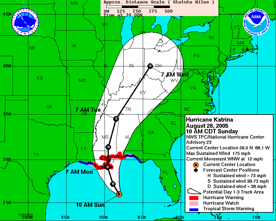
AT 10 AM CDT...1500Z...THE CENTER OF HURRICANE KATRINA WAS LOCATED
NEAR LATITUDE 26.0 NORTH... LONGITUDE 88.1 WEST OR ABOUT 225 MILES
SOUTH-SOUTHEAST OF THE MOUTH OF THE MISSISSIPPI RIVER.
KATRINA IS MOVING TOWARD THE WEST-NORTHWEST NEAR 12 MPH...AND A TURN
TOWARD THE NORTHWEST AND NORTH-NORTHWEST IS EXPECTED OVER THE NEXT
24 HOURS.
REPORTS FROM AN AIR FORCE HURRICANE HUNTER AIRCRAFT INDICATE THAT
THE MAXIMUM SUSTAINED WINDS HAVE INCREASED TO NEAR 175 MPH...WITH
HIGHER GUSTS. KATRINA IS A POTENTIALLY CATASTROPHIC CATEGORY FIVE
HURRICANE ON THE SAFFIR-SIMPSON SCALE. SOME FLUCTUATIONS IN
STRENGTH ARE LIKELY DURING THE NEXT 24 HOURS.
HURRICANE FORCE WINDS EXTEND OUTWARD UP TO 105 MILES FROM THE
CENTER...AND TROPICAL STORM FORCE WINDS EXTEND OUTWARD UP
TO 205 MILES.
THE AIR FORCE HURRICANE HUNTER PLANE RECENTLY MEASURED A MINIMUM
CENTRAL PRESSURE OF 907 MB...26.78 INCHES.
COASTAL STORM SURGE FLOODING OF 18 TO 22 FEET ABOVE NORMAL TIDE
LEVELS...LOCALLY AS HIGH AS 28 FEET ALONG WITH LARGE AND DANGEROUS
BATTERING WAVES...CAN BE EXPECTED NEAR AND TO THE EAST OF WHERE THE
CENTER MAKES LANDFALL.
RAINFALL TOTALS OF 5 TO 10 INCHES...WITH ISOLATED MAXIMUM AMOUNTS OF
15 INCHES...ARE POSSIBLE ALONG THE PATH OF KATRINA ACROSS THE GULF
COAST AND THE TENNESSEE VALLEY. RAINFALL TOTALS OF 4 TO 8 INCHES
ARE POSSIBLE ACROSS THE OHIO VALLEY INTO THE EASTERN GREAT LAKES
REGION TUESDAY AND WEDNESDAY.
ISOLATED TORNADOES WILL BE POSSIBLE BEGINNING THIS EVENING OVER
SOUTHERN PORTIONS OF LOUISIANA...MISSISSIPPI...AND ALABAMA...AND
OVER THE FLORIDA PANHANDLE.
REPEATING THE 10 AM CDT POSITION...26.0 N... 88.1 W. MOVEMENT
TOWARD...WEST-NORTHWEST NEAR 12 MPH. MAXIMUM SUSTAINED WINDS...
175 MPH. MINIMUM CENTRAL PRESSURE... 907 MB.
AN INTERMEDIATE ADVISORY WILL BE ISSUED BY THE NATIONAL HURRICANE
CENTER AT 1 PM CDT FOLLOWED BY THE NEXT COMPLETE ADVISORY AT 4 PM
CDT.
FORECASTER PASCH
That weather map is scary.
I hope everybody gets through it ok
Thoughts and prayers.
HOLY CANOODLES! It's headed straight for Bambaloo!
Very concerned. Mandatory evacuation underway. I grew up in Houston and I've seen this. I sincerely hope the aftermath is a great deal less extreme than we are currently imagining.
Prayers. Many hopeful prayers to all the people.
An odd note; this very event and it's far-reaching ramifications were depicted in a fictional movie called 'Oil Storm' on FX last month.
There is a deep fear in the pit of my stomach.
http://www.nola.com/bridgecam/
I love your Smiley Central emoticon. That's a good one.
Yes, My thoughts and prayers are with everyone that is going to be impacted by this-and its going to be a lot of people all week. Not just on the coast. Take care everyone, heed the warnings. Having gone thru 3 hurricanes last year I can tell you it is not fun... be safe and remember never to drive thru flooded intersections. Turn around.
My thoughts are with all of those who are in the path of Katrina...I wish I could add my prayers too, but that wouldn't be right since I don't have a faith.
I just hope that everyone will stay as safe as possible.
My thoughts and prayers go out to all those in the path.
Keeping my fingers crossed for your friends and family.
Sherri, Christa and Karen, thanks so much for your thoughts. All my family in NO have evacuated north and west.
This storm is scaring the **** out of me. I love the Big Easy.
I was just cruising by...
Post a Comment